Research
DroughtCast: A Machine Learning Forecast of the United States Drought Monitor
Colin Brust, John S. Kimball, Marco P. Maneta, Kelsey Jencso, Rolf H. Reichle
Abstract
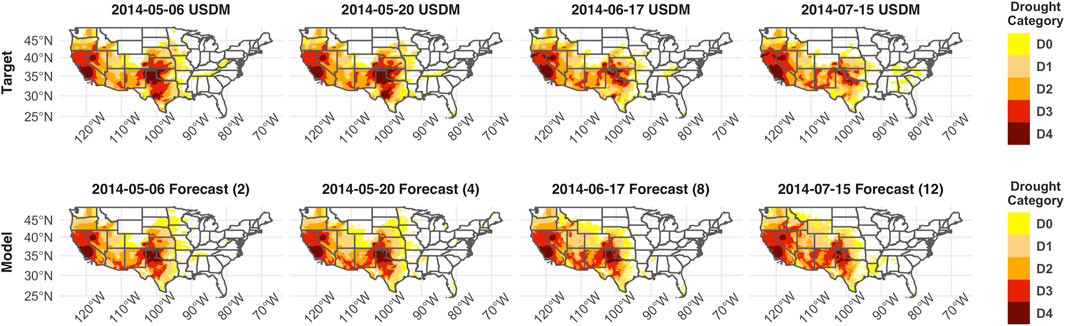
Drought is one of the most ecologically and economically devastating natural phenomena affecting the United States, causing the U.S. economy billions of dollars in damage, and driving widespread degradation of ecosystem health. Many drought indices are implemented to monitor the current extent and status of drought so stakeholders such as farmers and local governments can appropriately respond. Methods to forecast drought conditions weeks to months in advance are less common but would provide a more effective early warning system to enhance drought response, mitigation, and adaptation planning. To resolve this issue, we introduce DroughtCast, a machine learning framework for forecasting the United States Drought Monitor (USDM). DroughtCast operates on the knowledge that recent anomalies in hydrology and meteorology drive future changes in drought conditions. We use simulated meteorology and satellite observed soil moisture as inputs into a recurrent neural network to accurately forecast the USDM between 1 and 12 weeks into the future. Our analysis shows that precipitation, soil moisture, and temperature are the most important input variables when forecasting future drought conditions. Additionally, a case study of the 2017 Northern Plains Flash Drought shows that DroughtCast was able to forecast a very extreme drought event up to 12 weeks before its onset. Given the favorable forecasting skill of the model, DroughtCast may provide a promising tool for land managers and local governments in preparing for and mitigating the effects of drought.
Using SMAP Level-4 soil moisture to constrain MOD16 evapotranspiration over the contiguous USA
Colin Brust, John S. Kimball, Marco P. Maneta, Kelsey Jencso, Mingzhu He, Rolf H. Reichle
Manuscript Link | Request Manuscript
Abstract
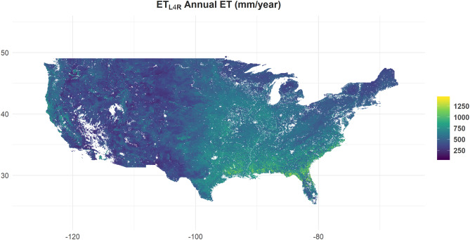
Evapotranspiration (ET) is a key hydrologic variable linking the Earth’s water, carbon and energy cycles. At large spatial scales, remote sensing-based (RS) models are often used to quantify ET. Despite the large number of RS ET models available, few include soil moisture as a key environmental input, which can degrade model accuracy and utility. Here, we use model assimilation enhanced soil moisture estimates from the NASA SMAP (Soil Moisture Active Passive) mission as a water supply control in the MOD16 ET algorithm framework. SMAP-derived daily surface (0-5 cm depth) and root zone (0-1 m depth) soil moisture are used with MODIS (Moderate Resolution Imaging Spectroradiometer) vegetation observations, and 4 km gridded regional surface meteorology (Gridmet) as primary inputs for estimating daily ET and underlying model soil and stomatal conductance terms. We calibrated the model environmental response parameters using tower eddy covariance ET observations representing major North American biomes. The model ET results were validated using a holdout set of tower observations spanning a large regional climate gradient. The updated ET estimates outperform the baseline MOD16 product across all tower validation sites (RMSE = 0.758 vs 1.108 mm/day ; R2 = 0.68 vs 0.45, respectively). Smaller relative improvements were obtained using a recalibrated model with 4 km Gridmet meteorology, but no soil moisture control (RMSE = 0.813 mm/day ; R2 = 0.66), indicating that these changes are essential for the improved model performance. The soil moisture-constrained model improvements and relative benefits from the SMAP observations are greater in arid climates, consistent with stronger soil moisture control on ET in water-limited regions. The use of SMAP soil moisture as an additional model constraint improves MOD16 regional performance and provides a new framework for investigating both soil and atmosphere controls on ET.